Pyramid Peak - Aspen Trip
- Elk Range
Summary
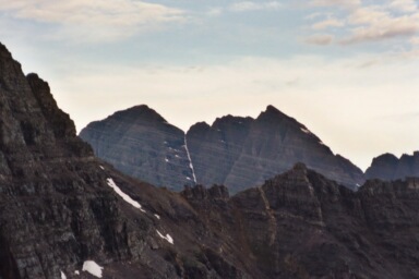
Pyramid Peak Elevation 14,023ft. (Jul. 27, 2003) "Northeast Ridge", trail from Maroon Lake TH. From this TH this class 4 trail runs (6.0 miles rt. with 4,450ft. gain). The trail starts with a nice valley walk for a mile until you leave the trail, and start your uphill climb. One of the keys to this route is to find the turn off of the "Carter Lake Trail". You need to look for a chard log and two cairns after 1.1 mile. The 1.1 mile mark comes after a switch back and a leveling off part of the trail. Do not be mistaken about the chard log, it is not blocking the trail, but rather marking the trail. The trail is well marked by cairns after the turn off and with some knowledge of the route you should have no trouble.
Read More Details or View Slideshow
Trip Schedule break down
| Saturday | 10:15AM | -summit Castle Peak See trip details. |
| Sunday | 3:45AM | -get up and drive to the Maroon Bells TH |
| 4:05AM | -leave Maroon TH. | |
| 8:45AM | -summit Pyramid Peak. | |
| 11:55PM | -back at the TH. | |
| 2:00PM | -beers at the Aspen Cantina. | |
| 5:00PM | -pick up Hilda from the kennel. | |
| 9:30PM | -arrive back in Denver. |
After the turn off, the trail heads for the amphitheater. The trail starts off going over patches of rock and dirt, the trail uses both cairns and logs to define the path. Once you get to the thick trees, the trail switchbacks un the steep slope to the amphitheater by weaving inbetween the tree and then ending up in a snow chute. The morning we did the climb there had been rain the previous night and this made the ground soft but not too muddy. We did however have to deal with the moisture from the trees and bushes ending up on our clothes.
Once in the amphitheater we meandered over the loose talus the the back of the amphitheater and then up the slope to the right (Northeast Ridge). On the way back we stayed on top of the snow field that ran the entire amphitheater, which made for a quick decent. From the amphitheater floor we went up the loose scree and talus toward the ridgeline. We ended up cutting across the top of the chute to gain the ridgeline in a more direct approach to Pyramids Northeast ridge. The hike around the back side of Pyramid was well marked with cairns and the green/white couloir was easy to recognize. The progress on the upper section was a little slow but less difficult then the route I took up El Diente or down Mount Wilson.
On the summit we met up with John and ended up stay with him for the entire trip down. Again, as I have become accustom to on other Elk Range summits, we saw an airplane flying below us. The "Northwest: ridge trail from the summit looked a little hard to follow and therefore we decided to return the same way we came up. The hike down went fairly quickly and we were back at the truck before we knew it.