Navajo Peak - Ward Day Trip
- Indian Peaks Range
Summary
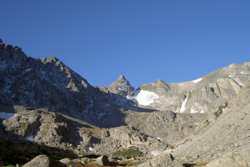
Navajo Peak Elevation 13,409ft. (September 17, 2005) "Airplane Gully" route from Long Lake trail head, Brainard Lake Recreation Area. From this TH, this class 1 to 3 trail runs (10.6miles rt. with 2,900ft. gain). There is a 7 dollar recreation entrance fee that can be paid at a drop box at the entrance. I arrived a the parking lot trail head with plenty of spaces to park. However, after my climb the parking lot and the entire Brainard Lake area was pretty full, some people had to walk the extra 1/2 mile from the Brainard Lake parking area to get to the Long Lake TH.
Read More Details or View Slideshow
Trip Schedule break down
| Saturday | 6:30AM | -left trail head |
| 10:30AM | -Summited Navajo Peak. | |
| 2:00PM | -back at trail head |
The trail is pretty straight forward until you get to the Isabelle Glacier turnoff. I for some reason I thought that you were suppose to go around the left side of Lake Isabelle, this was a mistake that took me off trail for an unpleasant bushwhacking experience. Once back on to the main trail on the far side of the lake I headed up to the Isabelle Glacier Trail turn off. The main trail takes you on the North side of Long Lake, Lake Isabelle, and a small glacial run off pond/lake. Some suggest going around the left side of this last water feature, but I can not say if there is really a trail over there.
On my ascent I went up the switchbacks to the North of this glacial run off lake and approached the Queens Way route for Apache Peak before cutting across the boulder/rock glacier into the upper Navajo Basin. On the way back I came straight over the lip of the upper basin and headed down a rock gully that took me to the South or left side of this previous glacial run off lake.
From the basin into Airplane gully is pretty easy. Airplane Gully is the easier looking gully to the left of Navajo Peak, or the second gully to the left of the peak. You will no you are in the right gully when you come upon the airplane wing and other debris at the entrance to the gully, and then the rest of the plane at the fork in the gully. At the fork you head to the right and reach the crest of the Niwot Ridge. From the crest, the trail heads for Navajo Peak which takes you up some switchbacks, formed from rock ledges, until you get to the chimney for the final ascent. The chimney is reached by heading around to the right or Northeast of the summit block. The chimney can be seen from the top of Airplane Gully and there is a cairn that marks the entrance (just don't go to far to the left when you head up the ledges and you will be fine). Once on the summit you can sit back and enjoy the views from this very distinct and small summit.