Harvard Group - Buena Vista Trip
- Sawatch Range
Summary
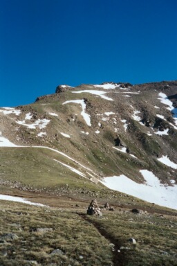
Mount Harvard and Columbia Elevation Harvard 14,427ft. Columbia 14,079ft. (June 28, 2003) "South Slopes of Harvard and North Slopes of Columbia via the traverse" trail from North Cottonwood Trailhead. The North Cottonwood trail up Mount Harvard and Columbia is a class 2 trail that runs (13.5 miles rt. with 5,900ft. gain). I arrived at the TH around 8:30PM. Friday night and only 15 minutes before Tim arrived. As we were arranging places to sleep, Tim managed to get his (Ford) truck stuck on a rock. I had to pull Tim's truck off of the rock using my (Chevy) truck, I wish that I had taken a few pictures of this. The trail the next day was long and the traverse from Harvard to Columbia did not have a well defined path, however we made the trek successfully.
Read More Details, View Slideshow
Trip Schedule break down
| Friday | 2:45PM | -see Mount Princeton climb |
| 8:30PM | -arrive at North Cottonwood Trailhead. | |
| Saturday | 5:25AM | -leave the TH to climb the Mount Harvard. |
| 9:15AM | -summit Mount Harvard via South Slopes. | |
| 12:50PM | -traverse ridge and Summit Mount Columbia. | |
| 4:35PM | -back at the TH. | |
| 7:00PM | -Margaritas at restaurant in Johnson's Village. | |
| 8:30PM | -arrive at Denny Creek TH. | |
| Sunday | 5:30AM | -see Mount Yale climb |
On this trip I adventured with Tim and his dog Hilda. Last year I climbed the Maroon Bells and La Plata with Tim, however this was my first time to hike with his dog. During the climb up Harvard, Tim and I played leap frog with Rex and Amy, two hikers that we would spend most of the day following or hiking together with. The hike up Harvard was great and there are some very large rock cairns in the valley leading up to the summit. The last 100 feet of the climb up Harvard involves a boulder scramble, which was the beginning of the trials for Hilda.
On the summit of Harvard we enjoyed the great views from the third highest peak in Colorado. After taking in the scenery we headed over to the traverse with Rex and Amy. The best route across the traverse may have been to drop down in to the valley to around 12,000ft., however we decided to stay high, descend a couloir, crossing a few snow fields, and then ascending the grassy slopes of Columbia. The route down the couloir was "arduous" as the Roach book says and we barely crossed the snow fields before they really became a post-holers delight. Hilda did fine on the snow, however the large boulders that were mixed in with the snow fields gave her more then she could handle alone.
After finally make it to the summit of Columbia, we enjoyed the company of some new hikers that had just arrived at the summit using the main trail up Columbia. After a short rest we descended the West slope and made the decision to go back to the main trail instead of an alternate route which followed a branch of cottonwood creek back to the main trail.
With about 1 mile of easy walking back to the TH left, a person came running out of the woods and on to the trail. This person was lost and a little flipped out, he had taken the trail down the creek that Tim and I had opted not to. This guy was telling us stories about going into survivor mode and drinking creek water, eating bark, etc. This guy had been lost for all of 15 minutes (another poor soul that could have prepared for his trip a little better, maybe a map, maybe a compass, how about even reading a trail description or looking at a map before his trip began).
After having enough fun on the trail we went to Coyote Cantina in Johnson's Village at the junction of 285 and 24. We had a couple drinks and some food before we parted ways; Tim went back to Denver and I when off to the Denny Creek TH for a climb of Yale on Sunday (continue to this trip).